


MARINE GPS/SBAS NAVIGATOR WITH VIDEO PLOTTER FUNCTION
Negotiable Min Order Quantity Unit
- Required Quantity
-
- Place of Origin
- China
- Brand name
- Matsutec
- Payment Terms
- T/T,Western Union
- Production method
- Negotiable
- Shipping / Lead Time
- Negotiable / Negotiable
Apply a video call to the Supplier

Shenzhen Huayang Technology (HK) Co., Ltd.
 China
China
- Verified Certificate
-
9

| Product name | MARINE GPS/SBAS NAVIGATOR WITH VIDEO PLOTTER FUNCTION | Certification | - |
|---|---|---|---|
| Category |
Radio & TV Broadcasting Equipment
Navigation & GPS Other Telecommunications Equipment |
Ingredients | - |
| Keyword | gps alarm , gps tracker , gps navigator touchscreen , marine gps navigator | Unit Size | - |
| Brand name | Matsutec | Unit Weigh | - |
| origin | China | Stock | - |
| Supply type | - | HS code | - |
Product Information
Matsutec
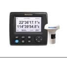
MARINE GPS/SBAS NAVIGATOR
WITH VIDEO PLOTTER FUNCTION
MODEL: HP-33
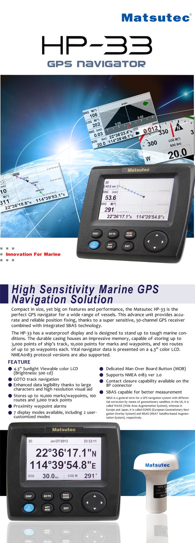
FEATURE:
1) Improved accuracy with built-in SBAS receiver
2) 4.3” Silver Bright LCD display
3) Multiple display modes to suit a varity of navigational requirements
4) Up to 10000 waypoint, 100 routes and 3000 track points
5) One-touch waypoint entry
6) Customizable Nav Data screens
7) Track back feature stores waypoints at user defined intervals for early trace-back cruise
8) Waypoint & Route upload/download through RS-232C port
DESCRIPTION:
The HP-33 is an advanced GPS navigator with a SBAS receiver designed for coastal ships, fishing boats and pleasure craft. The powerful processor performs high-speed processing of position fixing and augmentation using SBAS correction. It comes with an easy to use track plotter which stores up to 3000 track points.
This compact and cost-effective unit offers extremely accurate position fixes. It is accurate to 15 meters, and with SBAS mode activated, it's accurate to within 3 meters.
The display modes include Plotter, Nav Data, Steering, Highway, Satellite and two customizable modes. The Steering mode provides an intuitive indication of course to steer and crosstrack-error (XTE). The Highway mode is useful when you are heading for your fishing ground or following a series of waypoints along a planned route.
The user-friendly design permits easy and straightforward operation with minimum key strokes. The system has various alarm functions to warn of arrival to or departure from a predefined area (arrival/anchor watch), XTE exceeding a preset limit, Alarm Clock and more.
SBAS, Satellite-Based Augmentation Systems
An SBAS provider furnishes GPS signal corrections to SBAS users, for even better position accuracy, typically better than three meters. WAAS, available in North America, MSAS (Multi-Functional Satellite Augmentation System) for Japan and EGNOS (Euro Geostationary Navigation Overlay Service) for Europe, those are the provider in the worldwide SBAS (Satellite Based Augmentation System) navigation system. All providers will be compatible with one another, thus providing seamless position fixes to SBAS users. Major contributors of an error in a single frequency GPS system are a receiver clock drift and signal delays by refraction. The SBAS reference stations on the earth monitor the GPS constellation and route GPS error data to the
SBAS satellite via the master earth station. The Inmarsat or communication satellite broadcasts the differential corrections to users.
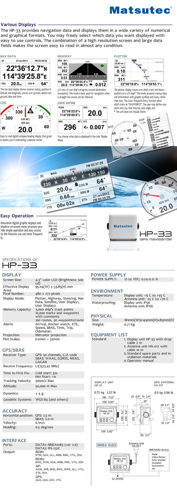
SPECIFICATIONS
1. GPS/SBAS
1) Receiver Type: GPS: Twelve discrete channels, C/A code, all-in-view. SBAS receiver.
2) Receiver Frequency: L1 (1575.42 MHz)
3) Time to First Fix: 15 second average (Hot start)
4) Tracking Velocity: 999 Knots
5) Geodetic System: WGS-84
2. Accuracy
GPS: 2.5m
SBAS: 2m
3. Display
4.3”color LCD(Brightness: 95.04(W) x 53.85(H) mm LCD, 480 x 272 pixels
4. Display Modes
Plotter, Highway, Steering, Satellite, Nav Date and 2 pages Customizable Display
5. Memory Capacity
3000 ship’s track points
10000 waypoints with comments
100 routes, 30 waypoint / route
6. Alarms
Arrival, Anchor watch, XTE, Speed, Time, Trip, Odometer
7. Language
English, Spanish, French, German, Dutch, Italian, Portuguese, Vietnamese, Indonesian, Chinese, Thai
8. Interface
Output (NMEA0183 ver 2.0)
AAM, APB, BOD, BWC, GGA, GLL, RMB, RMC, VTG, XTE, ZDA
9. Environment Temperature
Display unit: -15℃ to +55℃
Antenna unit: -25℃ to + 70℃
10. Waterproofing
Display unit: IPX5
Antenna unit: IPX6
11. Power supply
12–24 VDC, 240-120 mA
12. Equipment List
1) Display unit HP-33 with drop cable 2m
2) Antenna unit KA-07 with 10 m cable 1 set
3) Installation materials and spare parts 1 set
4) Operator manual
- Product Info Attached File
B2B Trade
| Price (FOB) | Negotiable | transportation | - |
|---|---|---|---|
| MOQ | Negotiable | Leadtime | Negotiable |
| Payment Options | T/T,Western Union | Shipping time | Negotiable |
- President
- Terry Du
- Address
- Unit 601,Bldg#614,Bagualing Industry Area,Futian District, Shenzhen City, China
- Product Category
- Navigation & GPS,Other Mobile Phones & Accessories,Other Telecommunications Equipment ,Portable Radio,Wireless Networking Equipment
- Year Established
- 2009
- No. of Total Employees
- 1-50
- Company introduction
-
Huayang Technology (HK) Co., Ltd. is a professional marine electronics company, we have professional sales team and quality products equipment, the spirit of "innovation and development, integrity-based " corporate philosophy, strive to create a first-Service platform. Huayang Technology products include Marine Radar , GPS navigation, fish finder, GPS chart plotter , ECS , ECDIS , Auto Pilot , AIS , AIS Sart , Radar Sart , Satellite phone of Inmarsat , Satellite phone of Iridium , Dock station for Inmarsat Isatphone pro , etc . Our products are mainly exported to Southeast Asia, North America and South America , and Middle Eest market . Through 10 years of development, the company already has an R & D team of 20 people, and to the continuous development and innovation for our customers to develop more advanced navigational equipment. Hua Yang Technology in the "innovation and development, good faith"concept, together with domestic and foreign counterparts in the field of marine electronic equipment continue to forge ahead, and dedication to provide the most complete marine electronics.
- Main Markets
-
 Albania
 Andorra
 Austria
 Bahamas
 Belgium
 Belize
 Canada
 France
 Macao(China)
 U.S.A
U.S.A
- Main Product


Related Products

Car DVR dual camera 3.5inch TFT LCD separate mirror dvrs Road safe guard rearview mirror car dvr

4X Zoom WiFi Action Sport DVR Camera Gropo Style Helmet Car DVR Electronics for Car Camcorder

Wholesale Tesla Style Rotation Screen Universal Car Radio

GPON OLT 4 X PON port and 2 X Uplink port (10/100/1000)

WIFI DVR MULTI USE FLASHLIGHT
