


Marine GPS Chart Plotter combowith Class B AIS transponder
Negotiable Min Order Quantity Unit
- Required Quantity
-
- Place of Origin
- China
- Brand name
- Matsutec
- Payment Terms
- Negotiable
- Production method
- Negotiable
- Shipping / Lead Time
- Negotiable / Negotiable
Apply a video call to the Supplier

Shenzhen Huayang Technology (HK) Co., Ltd.
 China
China
- Verified Certificate
-
9

| Product name | Marine GPS Chart Plotter combowith Class B AIS transponder | Certification | - |
|---|---|---|---|
| Category |
Radio & TV Broadcasting Equipment
Navigation & GPS Other Telecommunications Equipment |
Ingredients | - |
| Keyword | gps navigator , ais automatic identification system , ais transponder , gps chart plotter | Unit Size | - |
| Brand name | Matsutec | Unit Weigh | - |
| origin | China | Stock | - |
| Supply type | - | HS code | - |
Product Information
Matsutec
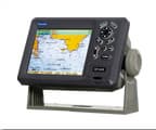
5.6" Color LCD Marine GPS/AIS chart plotter
Model: HP-628A
FEATURE:
1. High resolution TFT
day-view LCD display
2. SD-cards slot for C-map Max
and user data
3. C-map Max and K-chart
Selectable
4. Tide table
5. Versatile display modes
including:
-
Plotter Screen
- Nav Data
-
Satellite Information
- AIS
Display
-
Compass Screen
6. GOTO Track Navigation
7. Map Orientation Select
8. Proximity waypoint alarms
9. Perspective View
10. Palette
- Normal
- Daylight - Exposed to Sunlight
- Night - In Dark Environment
-
NOAA - Paper Chart Colors
-
Celestial
SPECIFICATIONS
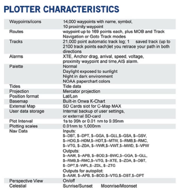
Plotter Characteristics
1. Waypoints/Icons: 14,000
waypoints with name, symbol, 10 proximity waypoint.
2. Route Memory:
waypoint up to 169 points each, plus MOB and Track Navigator or Goto track
modes
3. Tracks: 21,000 point
automatic track log; 10 saved track (up to 2100 track points each) let you
retrace your path in both derections
4. Alarm: XTE, Anchor Drag,
Arrival, Speed, Voltage, Proximity, Waypoint and Time, AIS alarm.
5. PALLETE
- Normal
- Daylight: Exposed to sunlight
- Night: In dark environment
- NOAA: Paper chart color
6. Tides: Tide Data
7. Projection: Mercator
projection
8. Position format: Lat/Lon
9. Base Map: Built-in ONWA K-Chart
10. External Map: SD cards slot for user
settings
11. User data storage: Internal backup of
user settings, or external SD-card
12. Plot Interval: 1s to 99h or 0.01nm to
9.99nm
13. 0.01nm to 1,000nm
14. Nav Data Input/Output:
- Input:
$--DBT, $--DPT, $--GGA, $--GLL, $--MTW,
$--RMA, $--RMB, $--RMC, $--VHW, $--VTG, $--ZDA
- Output:
$--AAM, $--APB, $--BOD, $--BWC, $--GGA,
$--GLL, $--RMB, $--RMC, $--VTG, $--XTE, $--ZDA, $--WPL, $--HDG
- Output for autopilot:
$--AAM, $--APB, $--BOD, $--VTG
15. PERSPECTIVE VIEW: On/off
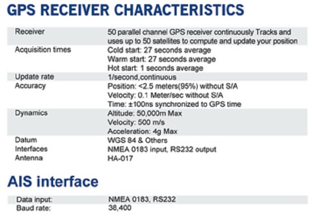
GPS Receiver Characteristics
1. Receiver: 50 parallel
channel GPS receiver continuously Tracks and uses up to 50 satellites to
compute and update your position
2. Acquisition: Cold
start: 27 seconds average
Warm
start: 27 seconds average
Hot start:
1 seconds average
3. Update rate: 1/second, continuous
4. Accuracy: Position: <2.5
meters(95%) without S/A
Velocity:
0.1 meter/sec without S/A
Time: ±100ns
synchronized to GPS time
5. Dynamics: Altitude: 50,000m
Max
Velocity:
500 m/s
Acceleration: 4g Max
6. Datum: WGS 84 & Others
7. Interface: NMEA 0183 Input ,
RS232 output
8. Antenna: HA-017
AIS Interface
- Data input: NMEA 0183, RS232
- Baud rate: 38400
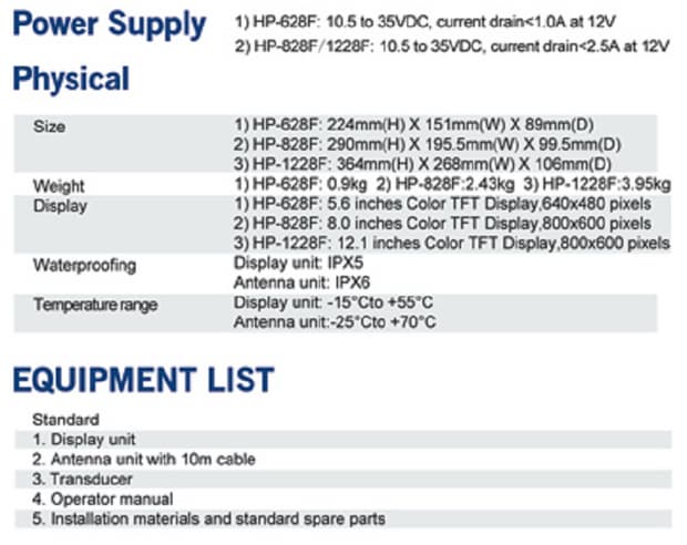
Power Supply: 10.5 to 35VDC,
current drain < 500mA at 12V
Physical
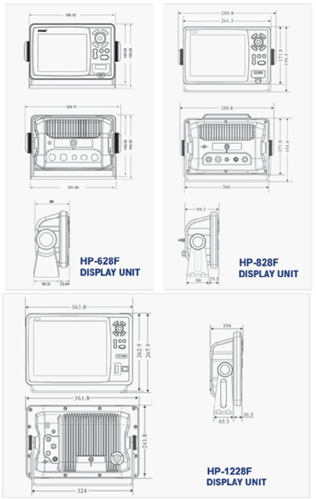
1. Size: 228mm(H) × 138mm(W) ×
79mm(D)
2. Weight: 0.9kg
3. Display: 5.6-inches color TFT day-view
LCD, 640 x 480 pixels
4. Waterproofing: Display unit: IPX5;
Antenna unit: IPX6
5. Temperature: -15°C to + 55°C (Display
unit); -25°C to + 70°C (GPS antenna)
AIS Characteristics
- Transmitter
x 1 ( For KP-628A only )
- Receiver
x 2 (one time shared between AIS/CDSC)
- Frequency
: 156.025 to 162.025 MHz in 25KHz steps
- Output
power : 2 Watts typical (For HP-628A only)
- Channel
bandwidth : 25KHz
- Channel
step: 25KHz
- Modulation modes :
25KHz GMSK (AIS, TX AND
RX)
25Hz AFSK (DSC, RX, only)
8. Bit
rate: 9600 b/s ± 50 ppm (GMSK)
1200
b/s ± 50 ppm (FSK)
9. RX sensitivity
: Sensitivity - 107dBm 25Khz
Message
error rate less than 2%
Co-channel
10dB
IMD
62dB
Bloching 84dB
Equipment List (Standard)
- Display unit
- Antenna unit with 10m cable
- Operator manual
- Installation materials and
Standard spare parts
- Product Info Attached File
B2B Trade
| Price (FOB) | Negotiable | transportation | - |
|---|---|---|---|
| MOQ | Negotiable | Leadtime | Negotiable |
| Payment Options | Negotiable | Shipping time | Negotiable |
- President
- Terry Du
- Address
- Unit 601,Bldg#614,Bagualing Industry Area,Futian District, Shenzhen City, China
- Product Category
- Navigation & GPS,Other Mobile Phones & Accessories,Other Telecommunications Equipment ,Portable Radio,Wireless Networking Equipment
- Year Established
- 2009
- No. of Total Employees
- 1-50
- Company introduction
-
Huayang Technology (HK) Co., Ltd. is a professional marine electronics company, we have professional sales team and quality products equipment, the spirit of "innovation and development, integrity-based " corporate philosophy, strive to create a first-Service platform. Huayang Technology products include Marine Radar , GPS navigation, fish finder, GPS chart plotter , ECS , ECDIS , Auto Pilot , AIS , AIS Sart , Radar Sart , Satellite phone of Inmarsat , Satellite phone of Iridium , Dock station for Inmarsat Isatphone pro , etc . Our products are mainly exported to Southeast Asia, North America and South America , and Middle Eest market . Through 10 years of development, the company already has an R & D team of 20 people, and to the continuous development and innovation for our customers to develop more advanced navigational equipment. Hua Yang Technology in the "innovation and development, good faith"concept, together with domestic and foreign counterparts in the field of marine electronic equipment continue to forge ahead, and dedication to provide the most complete marine electronics.
- Main Markets
-
 Albania
 Andorra
 Austria
 Bahamas
 Belgium
 Belize
 Canada
 France
 Macao(China)
 U.S.A
U.S.A
- Main Product


