


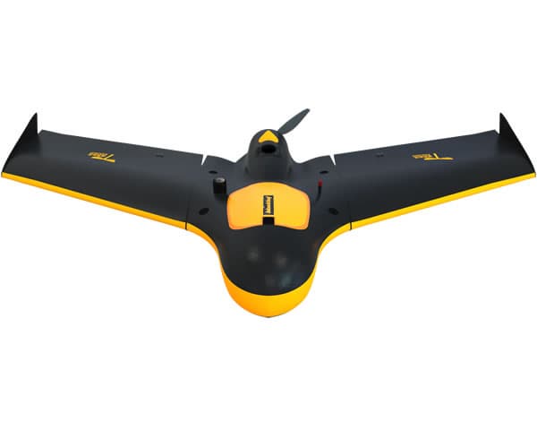
Blackbat Drone (UAV)
Negotiable Min Order Quantity Unit
- Required Quantity
-
- Place of Origin
- China
- Brand name
- ZINGTO
- Payment Terms
- L/C,T/T
- Production method
- Negotiable
- Shipping / Lead Time
- Negotiable / Negotiable
- Category
- Other Consumer Electronics
Apply a video call to the Supplier
Hebei Zingto Avigation Technology Co.,Ltd.
 China
China
- Verified Certificate
-
7

| Product name | Blackbat Drone (UAV) | Certification | - |
|---|---|---|---|
| Category | Other Consumer Electronics | Ingredients | - |
| Keyword | uav survey , uav power line inspection , uav environment monitor , uav urban planning | Unit Size | - |
| Brand name | ZINGTO | Unit Weigh | - |
| origin | China | Stock | - |
| Supply type | - | HS code | - |
Product Information
Quick Information
- Brand Name:ZINGTO
- Place of Origin:China
Description
Blackbat Drone
Card buckle design; fast disassembling; Industrial-grade communications equipment with long distance; eight frequency RTK; 24.3 million pixel
format cameras.
Features
High-definition cameras with SONY RX1R full-frame camera
Blackbat Drone (UAV) carry SONY RX1R full-frame camera with 24.3 million pixel resolution, through Kealyn flight control automatic control the high quality image data can be obtained. Through professional camera calibration; Data can be made seamless link with the post-processing software. Blackbat Drone (UAV) can also pick up other camera model according to customer need.
Remote communication
Long-distance communication/import industrial data transmission radio station.
Blackbat Drone (UAV) carries imported industrial data transmission radio, the ground side is the wireless data transmission “PRAJNA”, it can guarantee an unprecedented super-long communication distance, communication distance can reach 10 km.
"PRAJNA” makes wireless connections with ground station through WIFI signal, it perfect solved the overhead problem of the earth station antenna, and ensure the stable and reliable communication between UAV and the ground station.
Precise coordinates record Eight frequency RTK
Blackbat Drone (UAV) carries eight frequency RTK. Airborne-RTK, GPS module automatically boot record raw data, including GPS, GLONSS, BDS eight spectrum of pseudorange and carrier phase observation data, ephemeris data, the atmosphere correction data, etc., combined with the ground RTK and GPS the POS data can reach cm level through dedicated post-processing software.
Blackbat Drone (UAV) is suitable for high resolution aerial and aerial work, it can cut more than 80% of the fieldwork as the locus of control, and it greatly improve the efficiency of aerial and data precision.
RTK ground base station
Airborne RTK antenna
Dedicated ground station
Exclusive ground station All graphics interface
XT-GCS ground station system is designed for Blackbat Drone (UAV), it has the graphical interface and can set many intelligent operation modes, interface is simple and easy, operation logic is clear and simple; it can be adapted in many languages and meet the needs of different users.
Application
Blackbat Drone (UAV) is stable and reliable and has excellent performance, it has performed many tasks successfully . It has been tested by practice. Blackbat Drone (UAV) can be widely used in topographic mapping, coast, buildings, terrain, pipeline patrol, forestry survey of surveying and mapping, water conservancy, agricultural remote sensing and emergency investigation, power line selection, the disaster investigation, environmental monitoring, urban and rural planning, land law enforcement, and many other fields.
City 3D modeling; Forest protection monitoring; geological survey; crop monitoring; environmental monitoring; disaster prevention and reduction
Specification
| The Mission Payload | ||
| Camera | SONY ILCE QX1 | SONYRX1 |
| focal length | f = 20mm | f=35mm |
| sensor size | The APS format | full-frame format |
| pixels | 20.1 million | 2430mil |
| RTK | No | Yes |
| The Fuselage | ||
| Bird-up | 1300mm | |
| Wing area | 24dm2 | |
| Size | 1300×720×160mm | |
| Material of carbon fiber | Strengthening EPO | |
| Weight | 2200g, 2400g | |
| Configuration | ||
| Power | lithium polymer batteries, efficient brush-less motors | |
| Drive apparatus | XT- Z02 V1.1 | |
| Battery life | 95 min | 80min |
| Safety protection | lost star automatically; To complete the task automatically return; Safety height automatic open umbrella | |
| Take Off & Cruise & Land | ||
| Take off form | Ejection | |
| The cruising speed | 65km/h | |
| Landing form | Parachute landing form | |
| Wireless Digital | ||
| Communication frequency | 900MHz | |
| Communication control | > 10 km | |
| Operation | ||
| The system setup time | <10 min | |
| Flight level | 100-3000 m | |
| The default flight level | 247 m | |
| Overlap rate | Course direction70% | Slide direction50% |
| Weather request | Level 5 Wind resistance and slight drizzle | |
| Efficiency | ||
| 5 cm resolution | 6 km2 / vehicle | |
| 10 cm resolution | 10 km2 / vehicle | |
Price
- Price Condition :FOB
- Delivery Port :Tianjin
Packaging & Delivery
- Packing :in box or carton
- Delivery Lead Time :3-7 days
- Minimum Order :1 set
- Supply Ability :1000 set/month
Product Image
B2B Trade
| Price (FOB) | Negotiable | transportation | - |
|---|---|---|---|
| MOQ | Negotiable | Leadtime | Negotiable |
| Payment Options | L/C,T/T | Shipping time | Negotiable |
- President
- manager
- Address
- Lu Dao V Valley, building33, LuQuan District, ShiJiaZhuang, HeBei Province,China
- Product Category
- Other Machinery Parts
- Year Established
- 2015
- Company introduction
-
Hebei Zingto Avigation Technology Co.,Ltd. is a high-tech company dedicated to the development of unmanned aerial vehicles and supporting systems. Has passed ISO9001 quality system certification and EU CE certification.
Our company has the expert level technical team, such as the structure designer, appearance designer, aircraft aerodynamic analyst, software engineer, hardware engineer, control electronics engineer, communication electronic engineer and so on.Also they refined in the UAV system integration solution.
Our company is upholding the " integrity, innovation, truth - seeking, development" of the core values, insisting to the customer - oriented service concept, dedicated to the vast majority of customers in aerial applications, emergency command, aerial reconnaissance, agricultural protection, electrical inspection, electrical inspection, geological exploration and other areas to provide high-quality products and technical services.
- Main Product


Related Products
_2.jpg "Mixing Amplifier _SMA_1202A__1")
Mixing Amplifier (SMA-1202A)

Multy Fuction Hearing Neck Loop

TVLET Touch

Cafe Specialty A1_SELF-SERVE HOT & ICED CAFE MACHINE with various cashless payment system

EZ-CAM(EZ-500/EZ-500TTS)
